
OSE: Exploring Variations in Precipitation
TI-Nspire™ CX CAS
OSE: Exploring Variations in Precipitation
This simulation explores how elevation, distance from the shore, and precipitation are related.
This lesson is used as an alternative to the OpenSciEd: Unit 6.3- Lesson 21: Analyze Pacific Northwest and Gulf Coast Data
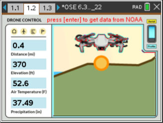
Students should follow the directions to run the TI-Nspire CX II simulations involving a virtual drone that can fly between different locations in the Pacific Northwest and Gulf Coast and collect data (elevation, precipitation, and air temperature). The data is graphed on the following page. Students will analyze precipitation, temperature, and elevation data at five locations along two different prevailing wind pathways to explore why there is less precipitation further inland in the Pacific Northwest than there is further inland from the Gulf Coast. They will model what happens as an air mass moves from above the ocean to locations over tall mountains and relatively flat landforms. Finally, they will develop a list of key ideas and data to explain climate patterns in places outside of the United States.
Lesson Files
TI-Nspire™ CX CAS
Vernier EasyData,Vernier EasyLink and Vernier EasyTemp are registered trademarks of Vernier Science Education.